← Home · Underground Excavations

Geotechnical Analysis for Soft Ground Tunnels in Grand Rapids

Together, we solve the challenges of tomorrow.

LEARN MORE →

ASCE 7 and the International Building Code set clear requirements for subsurface exploration, but around Grand Rapids the real challenge is the ground itself. Much of the city sits on glacial outwash and lacustrine clays deposited by the retreat of the Lake Michigan lobe, producing the soft, squeezing soils that complicate tunnel drives. A CPT test provides continuous stratigraphy without sample disturbance, which is critical when the target is a tunnel horizon that may vary by mere feet. Because the Grand River has reworked these deposits for millennia, the team cross-references CPT soundings with laboratory index tests to avoid surprises during excavation. Local knowledge of the valley fill—from the upland moraines of Kent County down to the floodplain—informs every boring plan. The result bridges code compliance and ground truth, reducing risk from the earliest design phase.

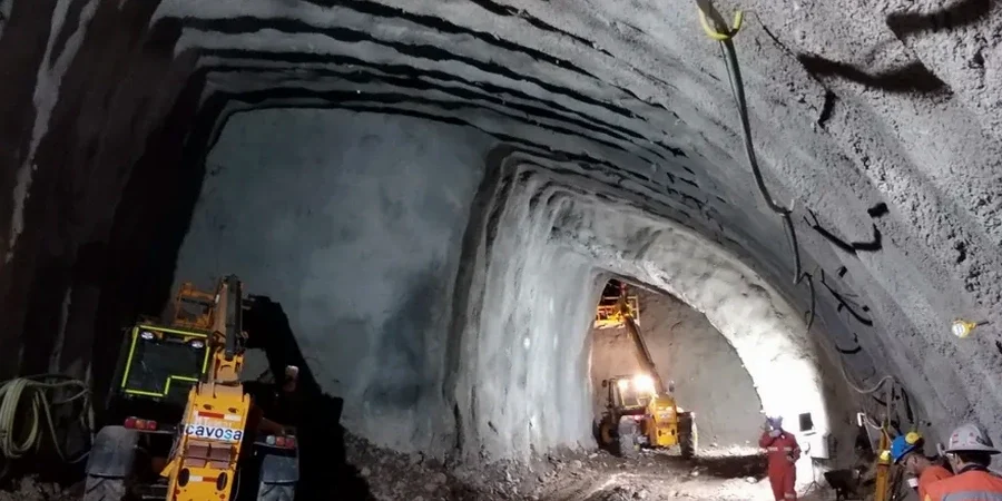
In Grand Rapids, the difference between a trouble-free drive and a stuck TBM often comes down to 5 feet of clay that nobody logged.

How we work

The glacial stratigraphy beneath Grand Rapids averages 60 to 120 feet of unconsolidated sediment over bedrock, with groundwater commonly encountered within 10 to 20 feet of the surface in the river corridor. That means a tunnel alignment near the Grand River is almost guaranteed to pass through saturated, low-plasticity silt or normally consolidated clay. A grain-size analysis quantifies the fines content that drives undrained behavior, while Atterberg limits flag plastic clays prone to face instability. These datasets feed directly into the selection of support pressure and face conditioning, whether the project is a microtunnel for sewer replacement or a larger utility bore under Michigan Street. The team also draws on historic boring logs from MDOT and city archives, correlating modern soundings with decades of subsurface data to map soft zones before the first cut is made.
Geotechnical Analysis for Soft Ground Tunnels in Grand Rapids
Technical reference image — Grand Rapids

Site-specific factors

The contrast between the northeast side’s sandy moraine ridges and the saturated clays of the Grand River floodplain is stark. On the Belknap Lookout side, tunnel alignment through dense outwash often allows open-face excavation with minimal support. Shift the alignment two miles southwest toward the river, and the same diameter tunnel encounters squeezing ground that can close behind the shield within hours. The biggest financial and schedule risk is failing to distinguish these units during the design phase; a few extra borings and a triaxial test suite can define the undrained strength envelope that governs face stability. When the data are sparse, contractors default to conservative—and expensive—support measures. The team closes that gap by mapping the transition zones between the Lake Border moraine and the valley train deposits, giving the owner a geotechnical baseline that holds up during construction.

Need a geotechnical assessment?

Reply within 24h.

Email: contact@geotechnicalengineering1.org

Typical values

ParameterTypical value
Typical depth to bedrock (downtown corridor)60 to 120 ft
Groundwater depth range10 to 20 ft below grade
Predominant soil type at tunnel levelLacustrine clay and glacial outwash silt
Standard penetration resistance (N60) in soft zones2 to 8 blows/ft
Undrained shear strength range300 to 800 psf
Applicable ASTM standard for samplingASTM D1586
Applicable ASTM standard for classificationASTM D2487

Complementary services

01

Subsurface exploration and sampling

Mud rotary and hollow-stem auger borings along the tunnel alignment, with Shelby tube sampling in soft clay zones.

02

In-situ testing program

CPT soundings for continuous stratigraphy, supplemented by vane shear tests where the clay is too soft for SPT.

03

Laboratory index and strength testing

Grain-size distribution, Atterberg limits, consolidated-undrained triaxial tests, and one-dimensional consolidation for settlement estimates.

04

Geotechnical baseline report

A defensible GBR that defines anticipated ground behavior, stand-up time, and groundwater control measures for the contractor.

Regulatory framework

ASCE 7-22, IBC 2021 (adopted by Michigan), ASTM D1586, ASTM D2487, ASTM D4767

Frequently asked questions

What is the typical cost range for a soft ground tunnel geotechnical investigation in Grand Rapids?

Most investigations for a short to medium-length tunnel in Grand Rapids fall between US$4,200 and US$18,790. The final figure depends on the number of borings, the depth to bedrock, and the laboratory testing suite required.

Why are the glacial clays along the Grand River so challenging for tunneling?

These clays are normally consolidated or lightly overconsolidated, with low undrained shear strength and high sensitivity. When disturbed, they lose structure rapidly and can squeeze into the excavation face, making face control and ground support critical from the portal to the reception shaft.

Which ASTM standards apply to a soft ground investigation for a tunnel?

ASTM D1586 governs the standard penetration test, ASTM D2487 covers the Unified Soil Classification System, and ASTM D4767 provides the procedure for consolidated-undrained triaxial compression tests on cohesive soils.

How many borings are recommended for a tunnel alignment in Grand Rapids?

There is no fixed number; the spacing depends on the variability of the glacial stratigraphy. In the Grand River corridor, where soil types can change within 200 feet, borehole spacing of 100 to 300 feet is common, with CPT soundings placed between borings to fill in the stratigraphic gaps.

Location and service area

We serve projects in Grand Rapids and surrounding areas.

View larger map